Brief History of Valencia Port
The coast line of Valencia, 4 km away from the historic city, is a long beach without shelters occupied for centuries by the marshland of an Albufera much more extensive than the present one. For this and other reasons, the history of our port is not obvious, but rather rather curious. We want to share it with you through three key moments.
The Pont de Fusta
For many centuries after the foundation of Valencia by the Romans in what we now call Ciutat Bella – Old Town (at that time a river island, Tiris), the area of the Poblados Marítimos was a fairly inaccessible extension of the marshes of L’Albufera, where a small pier probably existed since even before.
At the end of the middle ages is documented the granting of the royal “privilege” to build a Pont de fusta“ – timber quay in the already existing small town of El Grao, right after the creation of the Consolat del Mar – Sea Business hall, which gave trade and fishing in the area a legal framework.
From there began a centuries-long history (literally) of various attempts to establish a stone quay but, due to the accumulation of sandbanks that forced to lengthen the port every year, the lack of shelter and the river’s sediment floods, a stable structure that responded to the needs and commercial potential of the city could not be achieved.
Fishing boats were beached with the help of bulls, and deep-draught vessels used small boats to reach the port.

Did you know that…?
- During Roman times, the coastline was 2 km inland from the current coastline.
- In the 15th century Valencia, with 80,000 inhabitants, was the most populated city in the Corona de Aragon (kingdom formed by the current Aragón, Catalunya, Valencia and the Balearic Islands).
- The name pesca del bou – bull fishing is not due to the bulls that towed the boats into the beach sand, but to the shape of the nets that resembled two horns when they were dragged. Joaquin Sorolla pictured the practise in some of his paintings.
- For centuries the River Turia was navigable up to the city walls by small boats. Before the construction of the first stone quay, the possibility of dredging the river and making it navigable for all types of boats was considered as option.
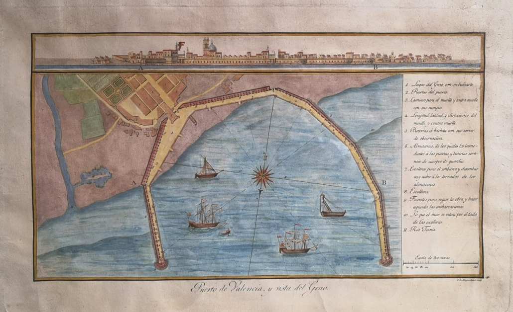
The Historical Dock
The 19th century witnessed great changes as a consequence of the Industrial Revolution.
With the development of new forms of life, many more industrialised European cities (with better quality of life) began to demand fresh fruit and vegetables, wine and raisins from Valencia, so that there was an urgent need to create a port and communications infrastructure in accordance with the region’s export capacity.
The railway came to provide the solution to the isolation of the port and is the final push to undertake the work that would create the current port structure with a polygonal basin head, a series of dykes to contain the contribution of sand, and a quay to the south that would displace the river with its constant contribution of sediments. Once built, the “new” harbour had to “dress up” to receive modern ships, their goods and passengers:
The art noveau sheds and docks were built to store fruit and vegetables for export, the Clock Tower served as the Maritime Passenger Station, the ramp and dry dock were the place for repair and maintenance of vessels, and the Customs Building was also erected to control the entry and exit of the port.
Fortunately we have preserved all of them, despite the fact that during the civil war of 1936 the port received more than 500 air raids and many other buildings were lost.
Did you know that…?

- In 1850 the first export of oranges, to the city of Liverpool, took place.
- The idea of the town of Cullera, South of Valencia city, becoming the port of Valencia and using the lake of L’Albufera as a canal to connect the two cities was considered several times.
- During the second half of the 19th century, on the terrace of the Miguelete (the cathedral’s bell tower) there was a mechanism of balls that were placed in different positions to inform of the arrival of commercial ships, their origin or destination. The so-called “port telegraph”..
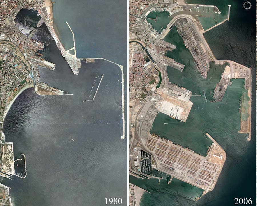
The America’s Cup
The first containers arrived to the port in 1979, and since the 80s of the last century, the commercial port has expanded dramatically to the south until it reached its present dimensions. Its construction even meant closing off access to the sea for an entire district of Valencia which had its own beach, Nazaret.
Later, in the early 2000s, the commercial port was separated from the Marina (including the fishing port) in preparation for the America’s Cup regatta, which for two years – 2007 and 2008 – was held in Valencia because the Swiss boat Alinghi, the defending champion, could not hold it in their country.
Between 2008 and 2012, a Formula 1 circuit race was also held in La Marina.
These major events brought changes to the Port and involved the construction of infrastructures which, with the arrival of the economic crisis and the end of cycle, fell into disuse but have now been socialised for the increasingly active enjoyment of visitors.
The most emblematic are the Veles e Vents building, which owes its name to a poem by Ausias March. It was built as a viewpoint and emblem of the America’s Cup and is now a cultural and gastronomic space. Also the rotating bridge of the F1 circuit which now just is set up for popular races and events.
An expansion of the port’s capacity is currently in play, based on a positive environmental impact report from 2007, but is being questioned for its incoherence in this context of climate crisis and de-growth.
Did you know that…?
- The city paid a high price for the America’s Cup. Directly to the shipowner a fee of 90 million Euros. After the America’s Cup, it has carried a debt of up to 400 million euros. The F1 circuit was also a huge outlay, plus the cost of the public company that was created to manage the events, and the fee that had to be paid for giving up the organisation of the competition.
- The commercial port of Valencia currently occupies an area of 5.5 million m2 and handles more than 4.5 million containers (TEU) per year. It means 41% of total Spanish exports and is the 5th most important port in Europe after Rotterdam, Hamburg, Antwerp and Piraeus.
Fonts
The main sources used to write and illustrate this blog have been the Complete History of the Port of Valencia on the web of Valencia Port, a wonderful book published by Valencia City Council “Los Poblados Marítimos, historia, lugares y escenas” and also the documentation of the exhibition “La dársena histórica del Puerto, progrés i modernitat” organised in La Torre del Reloj – The Bell Tower en 2018.
The header photo is a map by Cabanilles from 1975. The painting with a view of Valencia is by Alfred Guesdon, from 1858 (it is not medieval, but the situation of the port and teh city can be appreciated). The map of El Grao and Puerto de El Grao is from 1883. Finally, the comparative photos are from 1980 and 2006 respectively.

